
Project Engineer
September 2014 - June 2023 | SITARA Consult Pvt. Ltd, Nepal
As a Civil Engineer, I have been involved in various projects across Nepal, specializing in detailed engineering surveys, design, and report preparation for Integrated Check Posts (ICPs), Inland Clearance Depots (ICDs), hydrological studies, and road design. My responsibilities include grading design, drainage, stormwater management, site assessments, and compliance with environmental regulations. I have conducted hydrological and geotechnical investigations, developed roadway designs with safety and traffic optimization, and prepared detailed master plans and feasibility studies. Additionally, I have experience in analyzing flood risks, designing effective drainage systems, and integrating environmental considerations into infrastructure projects. Proficient in software like Civil 3D, ArcGIS, AutoCAD, HEC-RAS, and MS Office, I excel in preparing detailed documentation, cost estimates, and project reports while coordinating with multidisciplinary teams to ensure successful project execution.
Projects
Key Responsibilities:
1. Grading Design and Planning:
- Develop and design grading plans for construction sites, including cut-and-fill calculations, slope analysis, and land contouring.
- Prepare and review grading plans, ensuring compliance with local building codes, zoning laws, and environmental regulations.
- Collaborate with architects and civil engineers to integrate grading plans with overall site designs and infrastructure layouts.
2. Site Assessment:
- Conduct site assessments to evaluate soil conditions, topography, and drainage characteristics.
- Perform actively working with surveyors to gather accurate elevation data and define grades for foundations, roads, and parking lots.
- Identify and analyze any potential challenges, such as uneven terrain, existing structures, or environmental concerns that may affect grading.
3. Drainage, Road, Water Main Design and Stormwater Management:
- Design and implement effective drainage systems to manage stormwater and prevent erosion, including ditches, swales, culverts, and retention ponds.
- Perform Hydraulics and Hydrology Study of Site Area.
- Calculate the runoff volume after the increased of impervious area.
- Design the Circulation Road and Parking area, Water Line, Storm Sewer
- Prepare detailed design, drawings, and specifications, derive quantities, and derive unit rates, abstract of costs, and the bidding document.
- Land parcel cadastral with overlay of cadastral map from the district survey office and district survey office and district land revenue office.
- Obtaining a copy of the Land Ownership or Deed of each land parcels;
- Preparation of a conceptual plan of infrastructure required for ICD with tentative cost estimate.
- Ensure grading plans support effective water flow and prevent water accumulation or flooding around buildings and roads. Coordinate with environmental specialists to ensure that grading and drainage systems comply with local regulations on water quality and runoff.
4. Soil Analysis and Stabilization:
- Evaluate soil conditions and recommend appropriate soil stabilization methods if needed, including compaction, geotextile reinforcement, or soil amendments.
- Assess the need for geotechnical testing to verify soil bearing capacity and suitability for construction.
- Ensure proper excavation and compaction to prevent future settling or structural issues.
5. Coordination with Stakeholders:
- Work closely with project managers, contractors, and other engineering teams to ensure that grading work aligns with the overall construction schedule and budget.
- Provide technical support to construction teams during grading operations, ensuring work is executed according to plans and specifications.
- Collaborate with environmental consultants to address concerns related to soil erosion, vegetation preservation, and compliance with environmental guidelines.
6. Compliance and Regulatory Oversight:
- Ensure that all grading and site preparation activities adhere to regulatory requirements, including safety codes, zoning laws, and environmental standards.
- Prepare and submit necessary permits and documentation required for grading work.
- Conduct periodic site inspections to ensure grading activities are progressing as planned and conform to quality standards.
7. Reporting and Documentation:
- Prepare detailed grading reports, construction drawings, and project updates for stakeholders.
- Maintain records of soil tests, drainage systems, grading calculations, and design modifications.
- Document any issues or challenges encountered during the grading process and propose solutions.
8. Software Used:
- CIVIL 3D
- ARC GIS
- AUTOCAD
- MS EXCEL, MS WORD ETC.
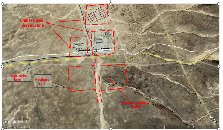
Study Area
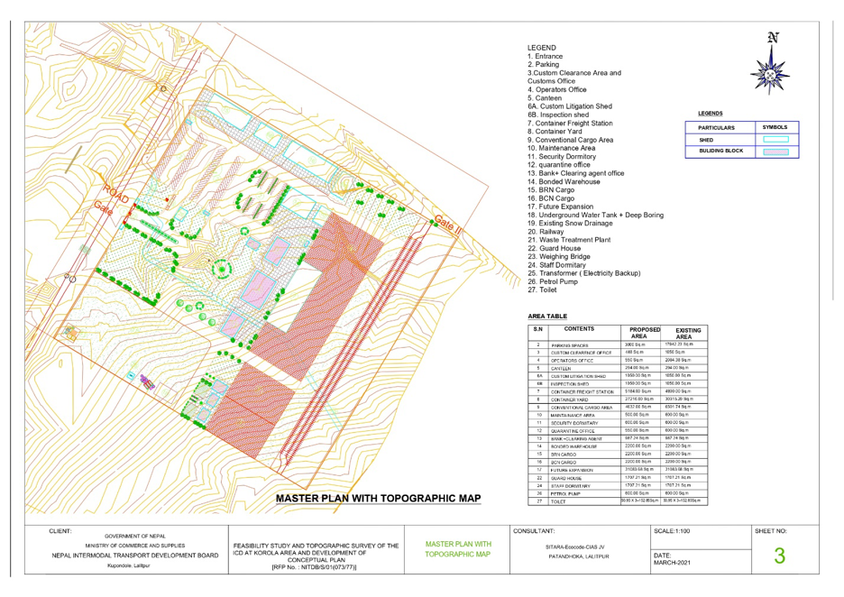
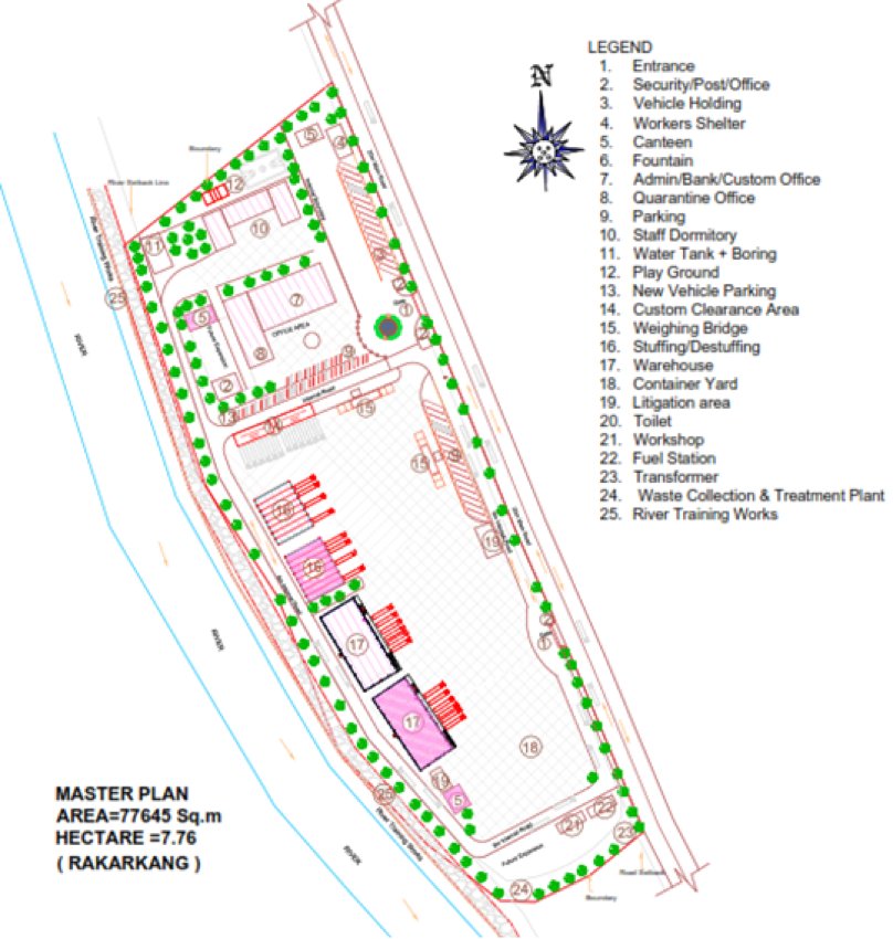
Site Grading Plan
Key Responsibilities:
- Study of Road and rail connectivity to the site.
- Development plans are under way on both sides of the border to improve connectivity and its timeline.
- Estimation of change in Exim traffic volume at border crossing points in the same or adjoining influence area on development of each of the proposed border crossing points.
- Extent of availability of government owned land for the development at the existing crossing point. Alternate location considering the security implications of moving the bonded area away from the international border.
- Present land use, degree of reliance of the local community on the traditional cross-border trade for their livelihood.
- Status of forest coverage and environmental degradation due to the envisaged development.
- Prepare the Site Grading Plan with Master Plan for the development of Inland Custom Deport.
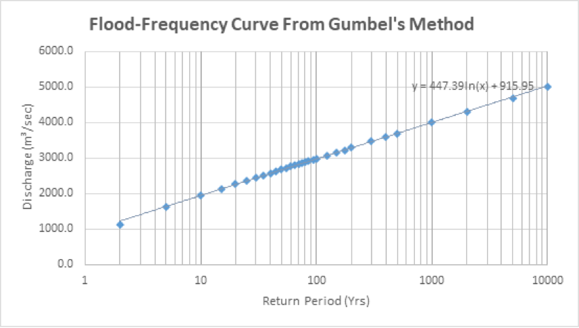
- Detail Study the Hydrology of the sites like Time of Concentration, Catchment area delineation, runoff volume for different return storm events, estimate the flow due to the increase in impervious area and study the different storm water management counter measure to reduced peak runoff
- Estimation of capital costs and operation costs for each phase of port development.
- Estimation of revenue generated and other economic benefits for each phase of port development.
- Analysis as per standard practices for the following with numerical and factual backup:
- Economic viability
- Financial viability
- Technical viability
- Environmental constraints
- Social constraints
- Identification of project risks and measures to address them.
- Sensitivity test for development of the locations.
- Recommendations based on the viability and risks discussed earlier.
- Software used:
- CIVIL 3D
- ARC GIS
- AUTOCAD
- MS EXCEL, MS WORD,ETC
Site Plan
Key Responsibilities:
1. Data Collection & Analysis:
- Collect historical and real-time river flow data, precipitation patterns, and water quality data.
- Use hydrological modeling software to predict river flow, flood events, and other relevant water dynamics.
- Analyze river stage, discharge, velocity, and sediment transport data to understand water flow behavior.
2. Flood Risk Assessment:
- Assess flood risk for the site, including both bank and extreme flood scenarios.
- Evaluate the recurrence intervals for high-water events (such as the 10-year, 50-year, or 100-year flood events) at the bridge location.
- Identify floodplain boundaries and potential flood impacts to the proposed bridge structure.
3. Hydrological Modeling:
- Develop and apply models such as HEC-RAS, to simulate river flow and behavior during different hydrological conditions.
- Conduct hydraulic modeling to understand the impact of the river's flow on the bridge's design, including scour potential, water velocity, and erosion effects.
4. Bridge Design Considerations:
- Provide hydrological input to the structural design team to ensure that the bridge can withstand floodwaters, extreme flow velocities, and sediment transport.
- Recommend floodplain management strategies such as embankment modifications, flood gates, or diversion channels.
- Determine the appropriate foundation depth and materials based on predicted water flow and scour effects.
5. Risk Mitigation:
- Identify potential hydrological risks such as scour, erosion, or sediment buildup around the bridge structure.
- Recommend design modifications or mitigation measures to address identified hydrological risks, such as scour protection or reinforced foundations.
6. Environmental Considerations:
- Assess the potential environmental impacts of the bridge and its construction on local river systems.
- Ensure that hydrological studies comply with environmental regulations and local ordinances.
7. Reporting & Documentation:
- Prepare comprehensive reports detailing hydrological findings, analysis, and recommendations.
- Provide visual aids such as flood maps, hydrographs, and river cross-section profiles to communicate findings clearly to project stakeholders.
- Collaborate with the project management team, civil engineers, and environmental specialists to integrate the study results into the overall project design.
Hydraulic parameters generated by HEC-RAS for designed flood simulation at Bridge
|
Plan: |
|
|
|
|
|
|
E.G. Elev (m) |
176.98 |
Element |
Left OB |
Channel |
Right OB |
|
Vel Head (m) |
1.61 |
Wt. n-Val. |
|
0.04 |
|
|
W.S. Elev (m) |
175.36 |
Reach Len. (m) |
50 |
50 |
50 |
|
Crit W.S. (m) |
174.66 |
Flow Area (m2) |
|
542.9 |
|
|
E.G. Slope (m/m) |
0.007374 |
Area (m2) |
|
542.9 |
|
|
Q Total (m3/s) |
3054 |
Flow (m3/s) |
|
3054 |
|
|
Top Width (m) |
124.86 |
Top Width (m) |
|
124.86 |
|
|
Vel Total (m/s) |
5.63 |
Avg. Vel. (m/s) |
|
5.63 |
|
|
Max Chl Dpth (m) |
7.64 |
Hydr. Depth (m) |
|
4.35 |
|
|
Conv. Total (m3/s) |
35565.3 |
Conv. (m3/s) |
|
35565.3 |
|
|
Length Wtd. (m) |
50 |
Wetted Per. (m) |
|
127.99 |
|
|
Min Ch El (m) |
167.72 |
Shear (N/m2) |
|
306.72 |
|
|
Alpha |
1 |
Stream Power (N/m s) |
11490.7 |
0 |
0 |
|
Frctn Loss (m) |
0.32 |
Cum Volume (1000 m3) |
|
266.05 |
|
|
C & E Loss (m) |
0.1 |
Cum SA (1000 m2) |
|
55.67 |
|
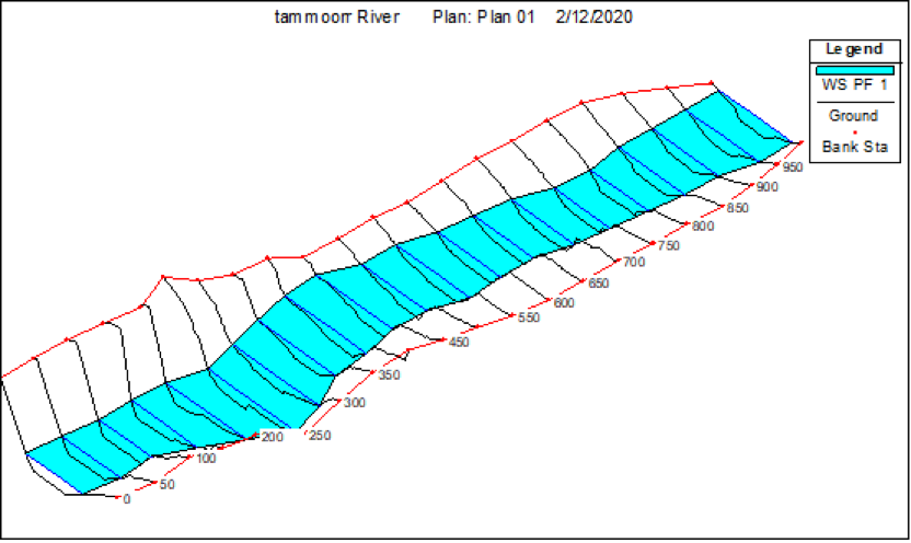
Figure: HEC-RAS geometry plan for bridge flood simulation
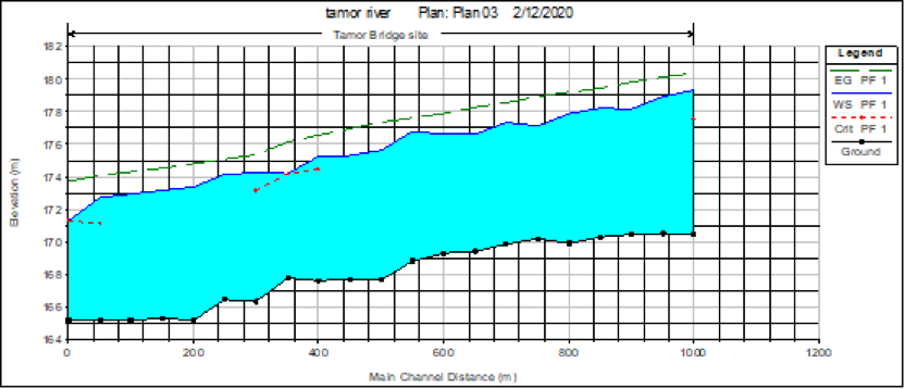
Figure: HEC-RAS energy profile simulated for 100 years flood
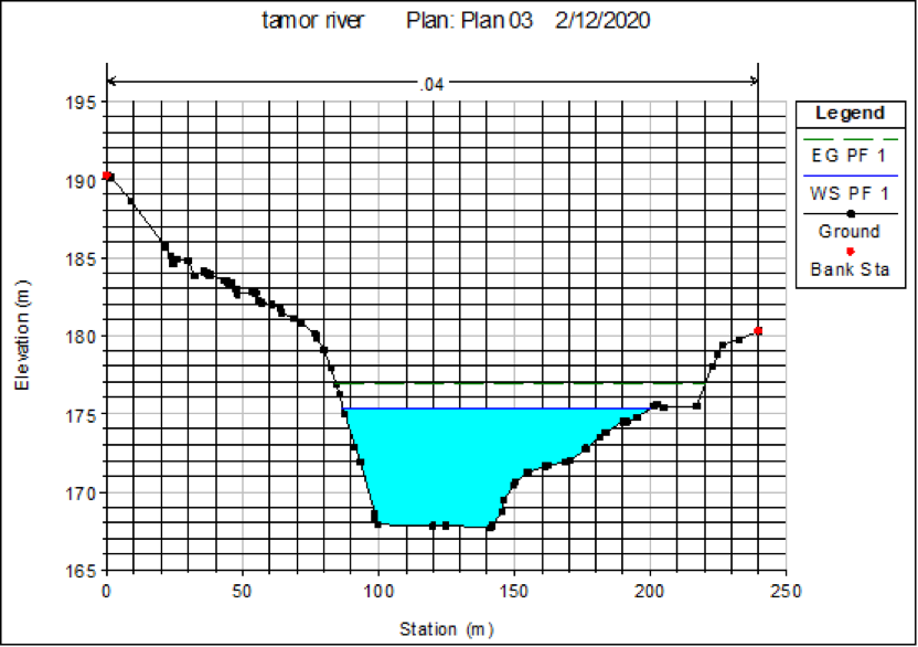
Figure: Cross Section at bridge axis as simulated by HEC-RAS for 100 years flood
8. SOFTWARE USED:
- HEC RAS
- ARC GIS
- MS EXCEL
- MS WORD ETC.
9. DATA USED FOR ANALYSIS:
- Topographical map
- Survey points
- Digital Elevation Model
- Historical River Discharge Data
- Precipitation data within the watershed
- Different Guidelines and Specification
Key Responsibilities:
1. Roadway Design and Planning:
- Develop comprehensive road design plans, including horizontal and vertical alignments, cross-sections, and pavement design.
- Plan and design road geometries (curves, intersections, turning radii, etc.) to optimize safety, efficiency, and traffic flow.
- Create detailed design specifications for road infrastructure, including materials, drainage systems
2. Traffic Analysis and Flow Optimization:
- Analysis to determine road capacity, traffic volumes, and patterns.
- Design and implement solutions to mitigate congestion, reduce travel times, and improve road safety (e.g., roundabouts, bypasses, or intersection upgrades).
- Evaluate and incorporate future traffic growth into design plans to ensure long-term sustainability of road infrastructure.
3. Geotechnical and Environmental Considerations:
- Assess and incorporate geotechnical data into the design, including soil types, compaction, drainage, and roadbed stability.
- Work with environmental consultants to ensure designs meet regulatory standards for environmental impact, including erosion control, water runoff, and habitat preservation.
- Address environmental concerns such as noise, pollution, and the impact on surrounding ecosystems.
4. Drainage and Stormwater Management:
- Design road drainage systems to prevent flooding, erosion, and water pooling, including culverts, storm sewers, swales, and retention ponds.
- Analyze hydrological data to plan for stormwater management systems that minimize environmental and structural risks.
- Ensure that road designs meet standards for water runoff, environmental impact, and local regulations.
5. Road Safety and Compliance:
- Implement safety measures in the road design, such as guardrails, signage, barriers, lighting, and pedestrian crossings, to improve safety for drivers, cyclists, and pedestrians.
- Ensure road designs meet local, state, and national transportation standards, codes, and regulations.
- Perform risk assessments to identify potential hazards and design mitigating measures (e.g., slope stabilization, flood mitigation).
6. Collaboration and Coordination:
- Collaborate with project managers, civil engineers, environmental consultants, and government agencies to integrate the road design into larger infrastructure projects.
- Liaise with stakeholders, including local authorities, the public, and other organizations, to address concerns and obtain necessary approvals and permits.
- Coordinate with contractors and construction teams to ensure the implementation of design plans is consistent with specifications.
7. Cost Estimation and Budgeting:
- Estimate project costs, including materials, labor, and equipment, and ensure designs are cost-effective and within budget.
- Review and modify designs to stay within the allocated budget while maintaining quality and safety.
- Monitor project progress to ensure that design elements are executed as planned and within financial constraints.
8. Project Documentation and Reporting:
- Prepare and present design documents, reports, and plans for review by clients, government agencies, or project stakeholders.
- Document design decisions, including design calculations, changes, and assumptions.
- Ensure that all design files, drawings, and data are properly maintained for future reference and regulatory compliance.
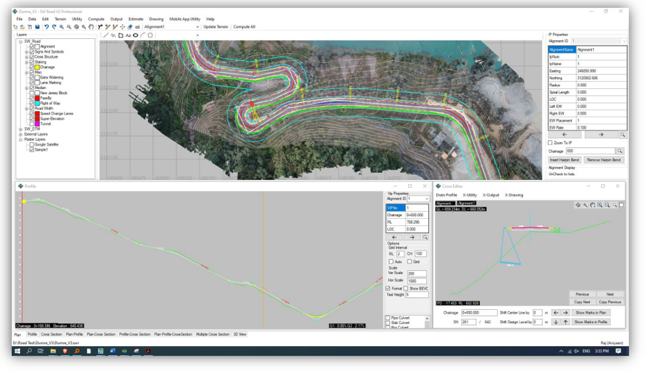
9. Different Step is Used in Road Design:
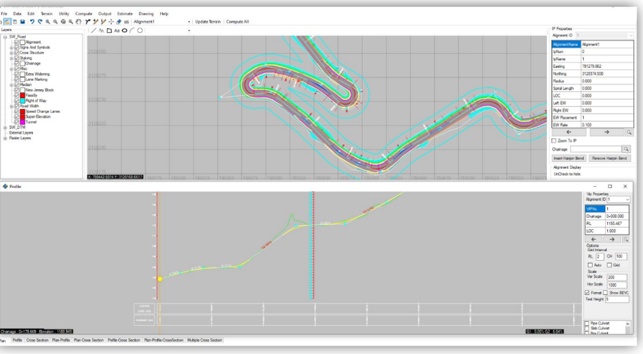
Draw Alignment and creating exiting profile and design Profile
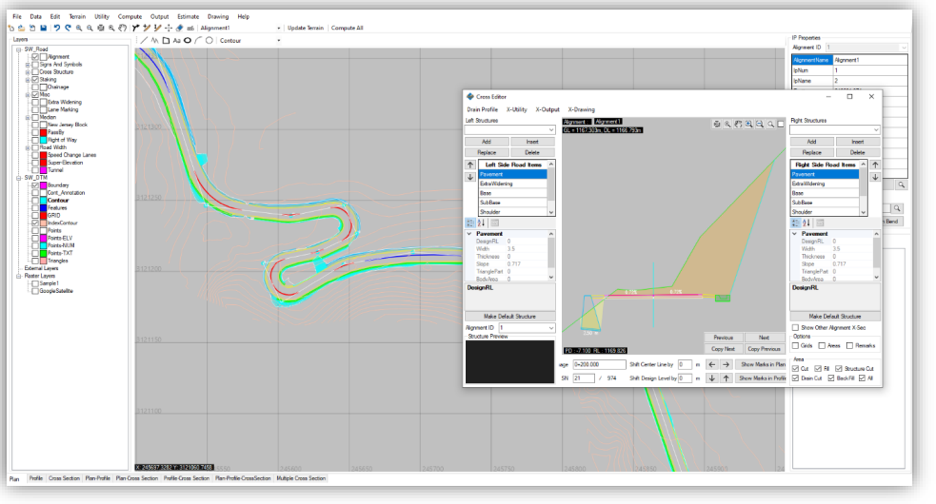
Designing the Road Section
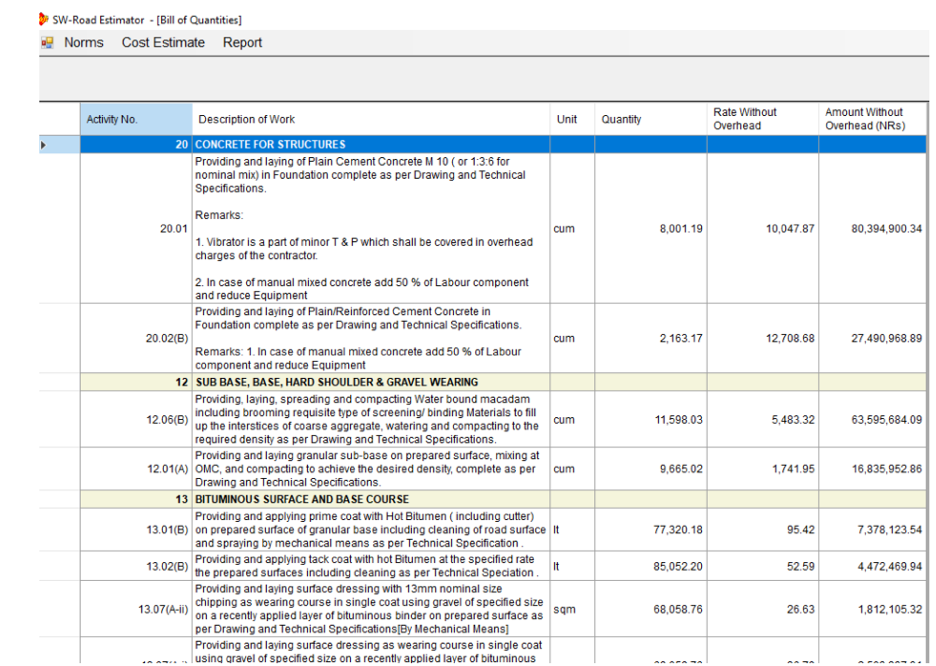
Preparation of Bill of Quantity and Budget Estimate
10. SOFTWARE USED:
- AUTOCAD
- SOFTWEL
- MS EXCEL, MS WORD ETC.
11. DATA USED FOR ANALYSIS:
- Topographical map
- Survey points
- Digital Elevation Model
- Different Guidelines, Specification