Land Surveyor
February 2007 - August 2013 | Nepal
Involved as Land Surveyor in different infrastructure development.
Key Responsibilities:
- Established primary control points along road corridors using GPS.
- Conducted road alignment staking using total station and DGPS.
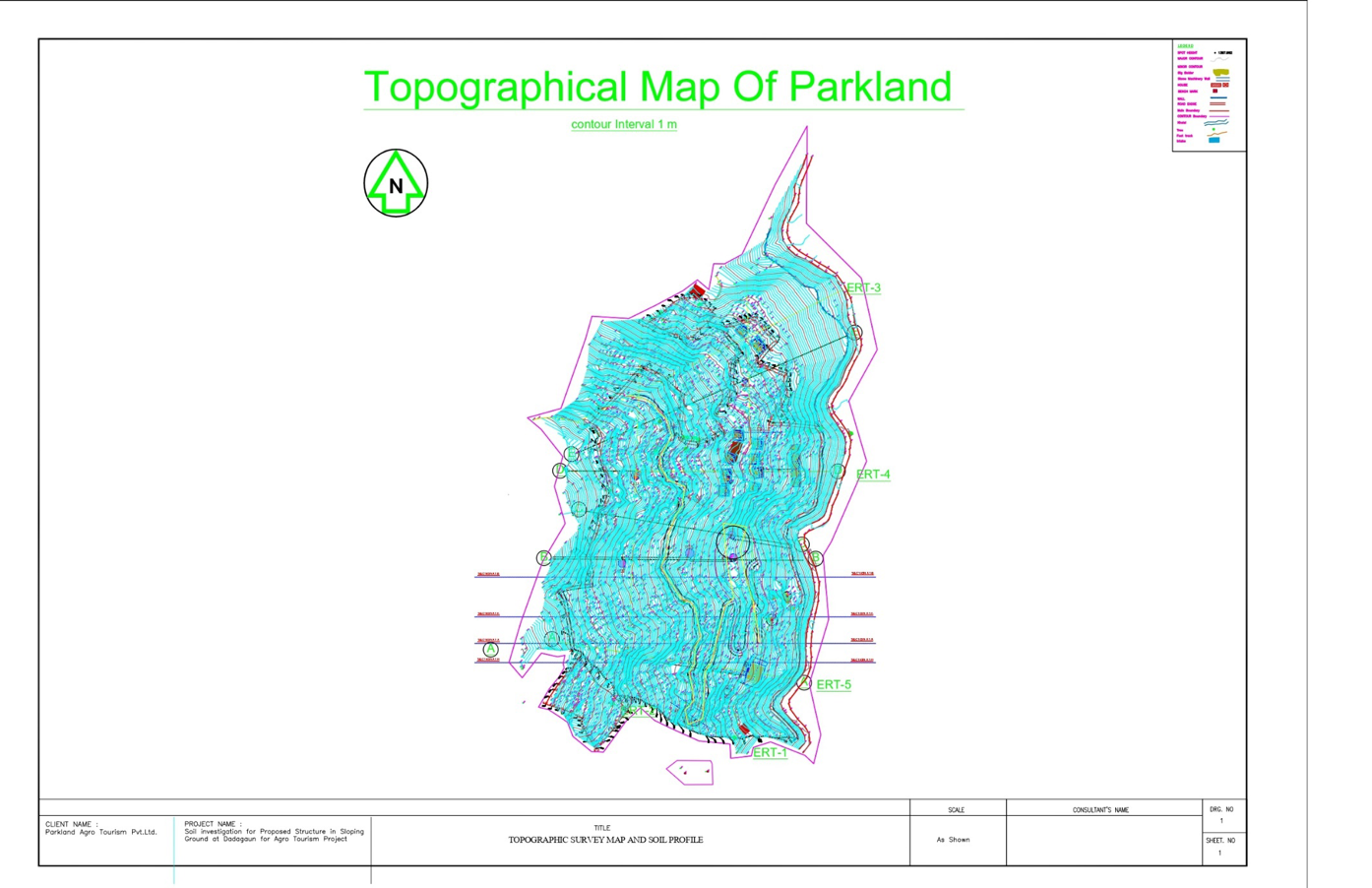
- Performed detailed topographical surveys, ensuring accurate data collection and mapping.
- Prepared topographic maps for road design and assisted team leaders in verifying land acquisition requirements and cadastral surveys along road alignments.
- Monitored and validated the accuracy of field surveys and data collection processes
Equipments Used:
- TOTAL STATION (TOPXON, PENTEX, SOKIA)
- DIGITAL LEVEL (SOKIA, TOPCON)
- DGPS (CARLSON, PENTEX, LEICA)
Softwares Used:
- AUTOCAD, CIVIL 3D
- TRIMBLE BUSINESS CENTER, FIELD GENIOUS, CARLSON SURVPC 7
- MS EXCEL, MS WORD ETC.
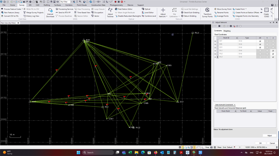
POST PROCESSING USING TRIMBLE BUSINESS CENTER
|
|
||||||||||||||||||||||||||||||||||
|
|
|||||||||||||||||||||||||||||||||||
|
|
|
|
|
|
|
Observation |
From |
To |
Solution Type |
H. Prec. |
V. Prec. |
Geodetic Az. |
Ellipsoid Dist. |
ΔHeight |
|
BASE --- DGPS-1 (B3) |
BASE |
DGPS-1 |
Fixed |
0.004 |
0.005 |
154°05'33" |
152.015 |
-0.185 |
|
BASE --- DGPS-2 (B1) |
BASE |
DGPS-2 |
Fixed |
0.004 |
0.005 |
291°18'56" |
168.384 |
-0.383 |
|
BASE --- DGPS-3 (B5) |
BASE |
DGPS-3 |
Fixed |
0.003 |
0.004 |
261°05'26" |
132.495 |
-0.435 |
|
DGPS-2 --- DGPS-1 (B2) |
DGPS-2 |
DGPS-1 |
Fixed |
0.004 |
0.005 |
131°33'26" |
298.392 |
0.192 |
|
DGPS-2 --- DGPS-3 (B4) |
DGPS-2 |
DGPS-3 |
Fixed |
0.003 |
0.004 |
162°22'09" |
85.757 |
-0.060 |
|
Acceptance Summary |
|
Processed |
Passed |
Flag |
|
Fail |
|
|
5 |
5 |
0 |
0 |
||


Coordinate Computation:
|
Point ID |
Easting |
Northing |
Elevation |
Station |
|
59 |
326927.788 |
2960581.176 |
76.278 |
DGPS-N1 |
|
60 |
326869.099 |
2961137.941 |
76.479 |
DGPS-N2 |
|
61 |
326820.135 |
2961596.001 |
76.283 |
DGPS-N3 |
|
62 |
327191.673 |
2962416.831 |
77.169 |
DGPS-N4 |
|
63 |
327562.090 |
2963306.693 |
77.527 |
DGPS-N5 |
|
65 |
327053.656 |
2964150.147 |
78.140 |
DGPS-N6 |
|
64 |
327326.700 |
2965082.005 |
78.810 |
DGPS-N7 |
|
67 |
327364.052 |
2965174.602 |
78.767 |
DGPS-N8 |
|
66 |
327698.210 |
2965997.641 |
79.106 |
DGPS-N9 |
|
68 |
327970.564 |
2966961.158 |
79.704 |
DGPS-N10 |
|
69 |
328251.617 |
2968656.621 |
80.192 |
DGPS-N13 |
|
Station |
H-angle |
H-Angle Correction |
Corrected H Angle |
Bearing |
Distance |
ΔE |
ΔE Correction |
ΔN |
ΔN Correction |
Easting |
Northing |
|
1002 |
241.2506 |
645964.75 |
3059561.12 |
||||||||
|
1001 |
92.6166 |
0.0013 |
92.61793 |
133.8685 |
328.47 |
283.07 |
0.007 |
-166.62 |
-0.001 |
645639.78 |
3059131.83 |
|
1007 |
208.097 |
0.0013 |
208.0983 |
141.9668 |
678.98 |
536.71 |
0.014 |
-415.87 |
-0.002 |
645922.86 |
3058965.21 |
|
1006 |
161.0168 |
0.0013 |
161.0181 |
102.9849 |
789.95 |
789.08 |
0.016 |
-37.03 |
-0.002 |
646459.59 |
3058549.34 |
|
1005 |
103.9847 |
0.0013 |
103.986 |
6.970977 |
800.41 |
87.47 |
0.017 |
795.61 |
-0.002 |
647248.68 |
3058512.31 |
|
1004 |
124.0118 |
0.0013 |
124.0131 |
330.9841 |
761.16 |
-672.78 |
0.016 |
356.00 |
-0.002 |
647336.17 |
3059307.92 |
|
1003 |
159.7146 |
0.0013 |
159.7159 |
290.7 |
706.20 |
-698.68 |
0.015 |
-102.80 |
-0.002 |
646663.40 |
3059663.92 |
|
1002 |
150.5492 |
0.0013 |
150.5505 |
241.2506 |
538.42 |
-324.97 |
0.011 |
-429.29 |
-0.001 |
645964.74 |
3059561.12 |
|
1001 |
645639.78 |
3059131.83 |
|||||||||
|
Sum |
999.9907 |
1000 |
4603.584 |
-0.10 |
0.10 |
0.01 |
-0.01 |
||||
|
corr |
0.10 |
-0.01 |
|||||||||
|
Actual |
1000 |
||||||||||
|
error |
-0.0093 |
||||||||||
|
correction |
0.0093 |
closing error e |
0.095847263 |
||||||||
|
P/e |
48030.41683 |
Traverse Computation